


Geological Overview
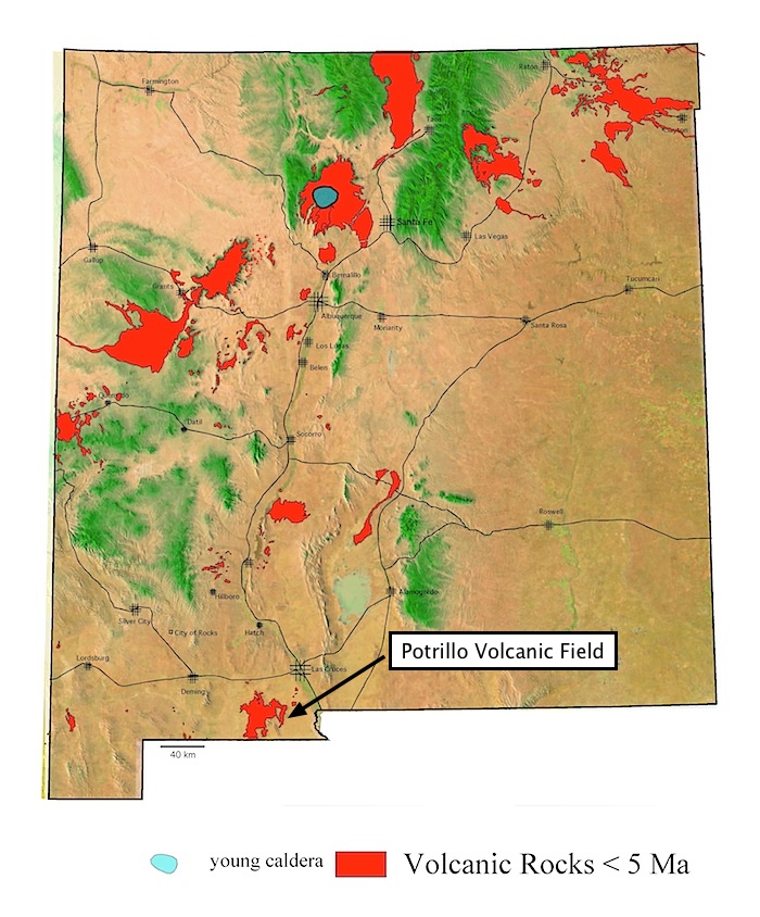
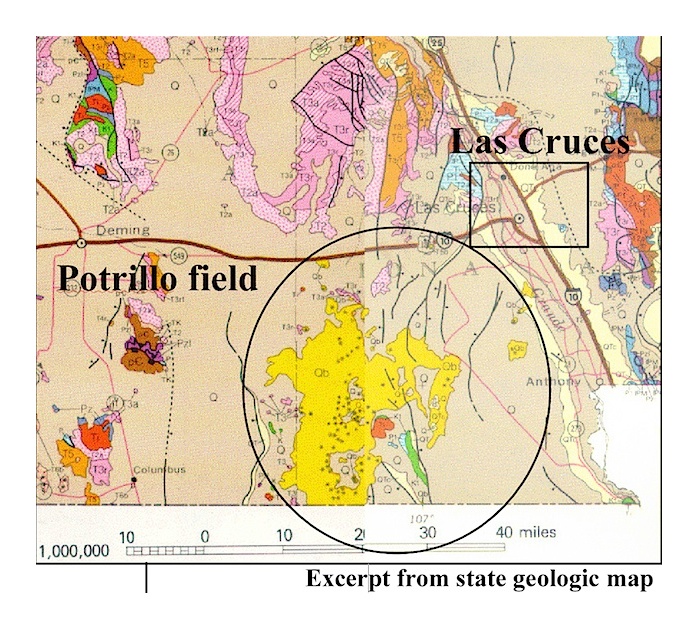
The Potrillo Volcanic Field is one of the youngest and mostly southerly fields in New Mexico. The young (~0-24 ka) eastern part of the field (Aden-Afton field ) (Hoffer et al, 1998) consists of several scoria cones, a shield volcano, and maars, as well as some much older basaltic masses such as Black Mountain. Three well-known maars, Hunt's Hole and Kilbourne Hole, and Potrillo, and a tuff cone, Riley occur in the eastern half of this field. The age of Kilbourne Hole is estimated at 80 ka, or approximately similar to Zuni salt Lake, another maar in northern and western New Mexico. Kilbourne Hole is widely known for its abundant mantle-lower crustal xenoliths (Padovani and Reid, 1989), but is better known in the volcanological community for its rim consisting of deposits emplaced through classic hydromagmatic base-surge eruptions, of which there are many excellent exposures.
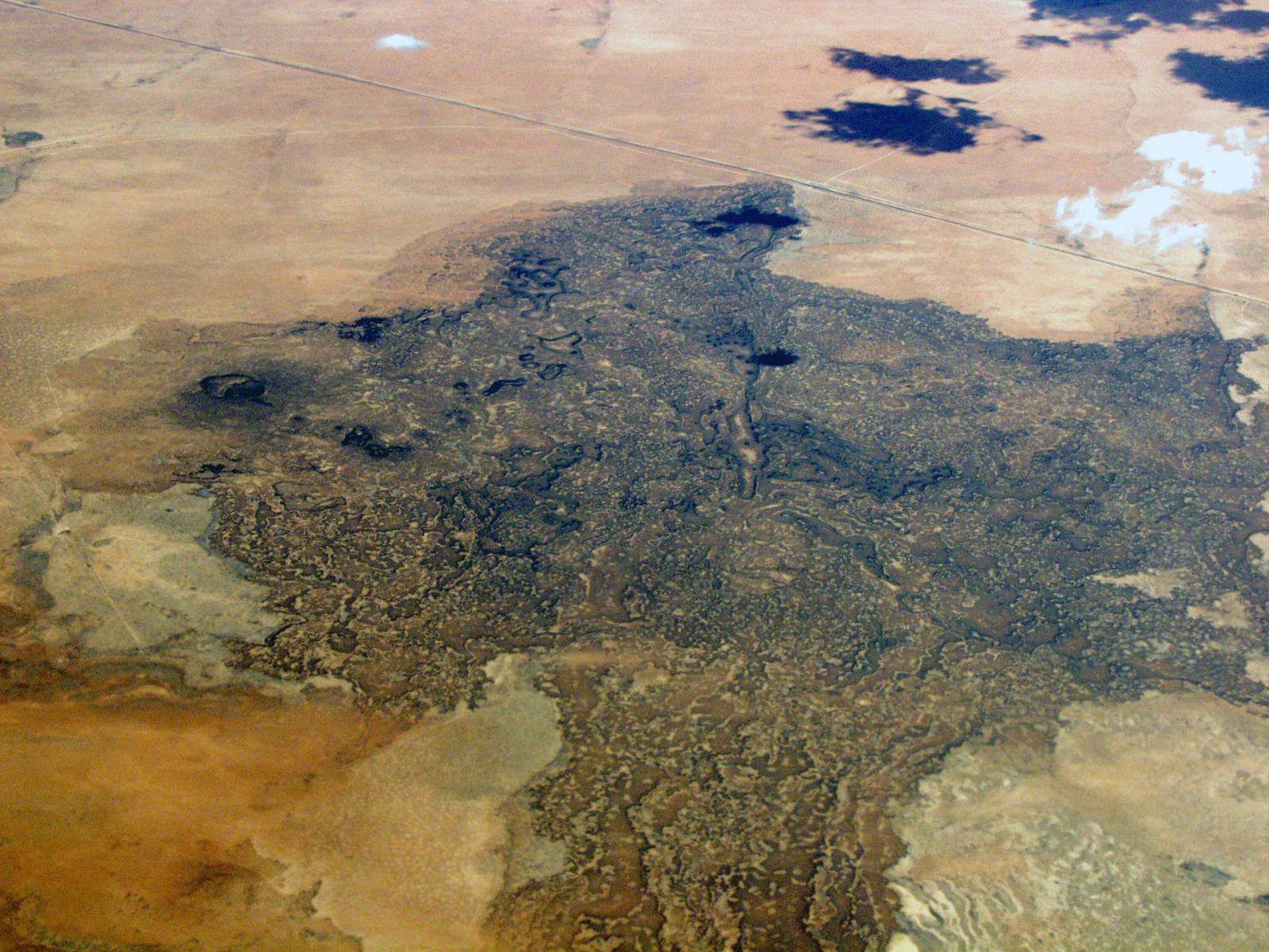
The western part of the field consists of more than a hundred basaltic scoria cones and is slighly older (~260-900 ka) (Hoffer et al, 1998)
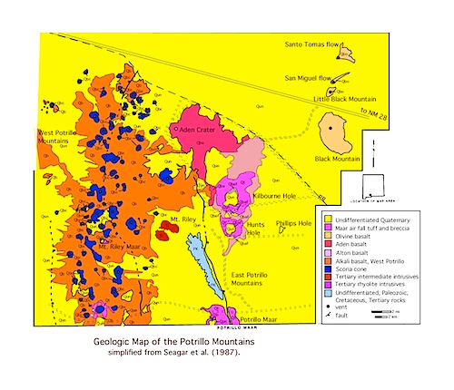
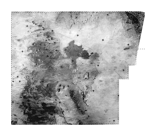
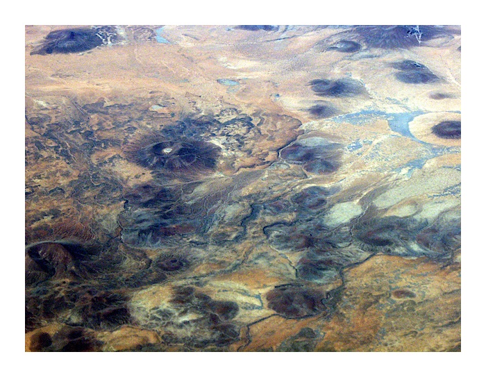
Aden Crater and surrounding lava flow field. This is a relatively young eruption (~20-24 ka) (Hoffer,1998). The vent area (left or west) margin of dark flow field area) is a shield volcano with a central platform and an extensive field of surrounding la a flows. The size and shape is typical of several other oate Cenozoic shield volcaneos and large lava flow fields in New Mexico. (For example, see the decsription and images from the Jornada del Muerto field. Maxim Crater, El Tintero, Cerro Verde, or San Felipé). High altitude photo by L. Crumpler.
Potrillo (Aden-Afton Basalt) Volcanic Field (western portion). High altitude photo by L. Crumpler.
References
Bersch, M. G., 1977, Petrography and geology of the southern West Potrillo basalt field, Doña Ana County, New Mexico [M.S. thesis]: University of Texas, El Paso, 60 pp.
Darton, N. H., 1911, Explosion craters. Scientific Monthly, v. 2, p. 417-430.
Dehon, R. A., 1965, Maar of La Mesa: New Mexico Geological Society 16th Field Conference Guidebook, Southwestern New Mexico, p. 204-209.Dehon, R. A., 1965, The geology of Hunt’s Hole [M.S. Thesis]: Texas Technical College, 70 p.
Gile, L. H., 1990, Chronology of lava and associated soils near San Miguel, New Mexico: Quaternary Research, v. 33, p. 37-50.
Gile, L. H., 1987, A pedogenic chronology for Kilbourne Hole, southern New Mexico: Soil Science Society of America, Journal 51, p. 746-760.
Gunn, G. R., 1980, Volcanic stratigraphy and structure of the La Mesita-Black Mesa area, southeast San Luis Valley, north central New Mexico [M.S. thesis]: Southern Methodist University, Dallas, 76 pp.
Hoffer, J. M., 1969, The San Miguel lava flow, Doña Ana County, New Mexico: Geological Society of America Bulletin, v.80, p.1409-1414.
Hoffer, J. M., 1971, Mineralogy and petrology of the Santo Tomas-Black Mountain basalt field, Potrillo volcanics, south-central New Mexico: Geological Society of America Bulletin, v. 82, p. 603-612.
Hoffer, J. M., 1975, The Aden-Afton basalt, Potrillo volcanics, south central New Mexico: Texas Journal of Science, v. 26, p. 379-390.
Hoffer, J. M., 1976, Geology of the Potrillo basalt field, south-central New Mexico: New Mexico Geological Society Special Publication 5, p. 89-92.
Hoffer, J. M., 1976, Geology of the Potrillo basalt field, south-central New Mexico: New Mexico Bureau of Mines and Mineral Resources Circular 149, 30pp.
Hoffer, J. M., and Corbitt, L. L., 1991, Evolution of the late Cenozoic Jornada volcano, South-Central New Mexico: New Mexico Geological Society 42nd Field Conference Guidebook, Sierra Blanca, Sacramento, Capitan ranges, p. 159-163.
Hoffer, J. M., Chen, W., McLemore, V. T., and Anthony, E. Y., 1991, Day 2: The Potrillo volcanic field; in Julian, B., and Zidek, J., (eds), Field Guide to Geologic Excursions in New Mexico and adjacent areas of Tecas and Colorado: New Mexico Bureau of Mines and Mineral Resources Bulletin 137, p. 12-19.
Hoffer, J. M., B. S. Penn, O. A. Quezada,and M. Morales, 1998. Qualitative age relationships of late Cenozoic cinder cones, southern Rio Grande rift, utilizing cone morphology and Landsat thematic imagery:a preliminary assessment, New Mexico Geological Socir=ety Guidebook, 49th Field Conference, Las Cruces Country II, 123-128.
Kahn, P. A., 1987, Geology of Aden Crater, Doña Ana County, New Mexico [M.S. thesis]: University of Texas, El Paso, 90 pp.
McIntosh, W. C., 1994, 40Ar/39Ar geochronology of late Miocene to Pleistocene basalts of the Zuni Bandera, Red Hill-Quemado and Potrillo Volcanic Fields: New Mexico Geology, v. 16, p. 6061
Ortiz, T. S., 1979, Megacrysts and mafic and ultramafic inclusions of the southern West Potrillo Basalt Field, Doña Ana County, New Mexico [M.S. thesis]: University of Texas, El Paso, 95 pp.
Padovani, E. R., and Reid, M. R., 1989, Field guide to Kilbourne Hole maar, Doña Ana County, New Mexico; in Chapin, C.E. and Zidek, J., (eds), Field Excursions to Volcanic Terranes in the western United States, v. 1, Southern Rocky Mountains, International Association of Volcanology and Chemistry of the Earth's Interior: New Mexico Bureau of Mines and Mineral Resources Memoir 46, p.174-179.
Page, R. G., 1975, Malpais maar volcano: New Mexico Geological Society 26th Field Conference Guidebook, p. 135-137.
Reeves, C. C., and Dehon, R. A., 1965, Geology of Potrillo maar, New Mexico and northern Chihuahua, Mexico: American Journal of Science, v. 263, p. 401-409.
Reiche, P., 1940, The origin of Kilbourne Hole, New Mexico: American Journal of Science, v. 238, p.212-225.
Shoemaker, E. M., 1957, Primary structures of maar rims and their bearing on the origin of Kilbourne Hole and Zuni Salt Lake, New Mexico: Geological Society of America Bulletin, v. 68, p.1864
Seager, W. R., 1995, Geology off the southwest quarter of Las Cruces and northwest El Paso 1 x 2° sheet, New Mexico: New Mexico Bureau of Mines and Mineral Resources, Geologic Map 60, 1: 125,000 scale.
Seagar, W. R., 1987, Caldera-like collapse at Kilbourne Hole maar, New Mexico: New Mexico Geology, v. 9., p. 69-73.
Seagar, W.R., Hawley, J.W., Kottlowski, F.E., and Kelley, S.A., Geology of the easy half of the Las Cruces and northeast El Paso 1° x 2° sheets, New Mexico: Ne Mexico Bureau of Mines & Mineral Resources, geologic Map 57, scale 1:125,000, 1987.
Seagar, W. R., Shafiqullah, M., Hawley, J. W., and Marvin, R., 1984, New K-Ar dates for basalts and the evolution of the southern Rio Grande rift: Geological Society of America, Bulletin, v. 95, p. 87-99.
Simon, E. L., and Alexander, H. L., 1964, Age of the Shasta ground sloth from Aden Crater, New Mexico: American Antiquity, v. 29, p. 390-391.
Stuart, C. J., 1981, Hunt’s Hole Maar volcano, Doña Ana County, south-central New Mexico: El Paso Geological Society Guidebook, p. 64-72.
.
View Potrillo Volcanic Field Link in a larger map