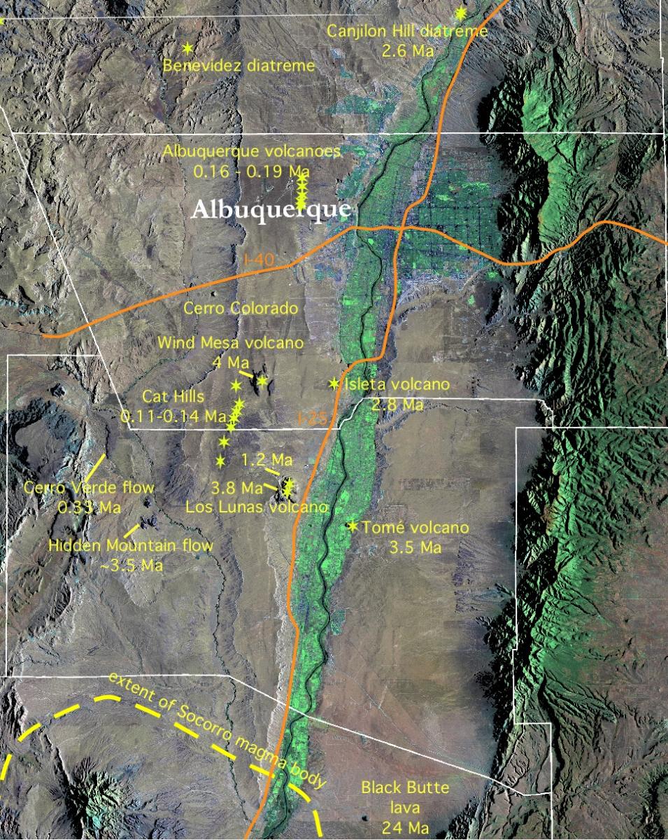
Summary of Locations and Known Ages of Volcanoes in the Albuquerque Basin, Rio Grande rift

Cat Hills

Aerial view north of the central part of the Cat Hills volcanoes alignment.-photo L. Crumpler

South Cat Hills cone.-photo L. Crumpler

South Cat Hills scoria cone viewed from the south. -Photo L. Crumpler
One of the youngest eruption sites in the Rio Grande rift, this Cat Hills scoria cone has been completely quarried away. -Photo L. Crumpler
Wind Mesa Volcano
While technically speaking they are not part of the Cat Hills Volcanoes, the Wind Mesa volcano (4 Ma) is a prominent part of the landscape to the immediate north of the Cat Hills and West of the Isleta volcano. This view from Tomé volcano loks across the Rio Grande valley floor. One of the Cat Hills cones may be seen on the left. -photo L. Crumpler

This northward-directed aerial view of Wind Mesa volcano shows the central graben that cuts through the volcano. The center of the volcano is near the center of the image consists of scoira and is presumably the source of most of the lavas. In the distance on the horizon to the north is the profile of the Valles Caldera. The Rio Grande valley and the Sandia Mountains are on the right.-photo L. Crumpler

Isleta shield volcano is just west of the Rio Grande and east of Wind Mesa volcano.. Lava flows from the Isleta shield volcano are responsible for the "isleta" of Isleta Pueblo. These lava flows are exposed in a road cut by I-25 between Albuquerque and Los Lunas just south of the overpass at Coors Blvd. -Photo L.Crumpler.
Los Lunas Volcano

View directed south over the three eruption sites of the Los Lunas volcano. The near end is a natural section through a late scoria cone resulting from slumping of the north flank. The oddly circular lavas on the left are part of the more andesitic eruptions that took place from the center of the composite of three eruption sites. While it is possible that the circularity is a result of symmetrical "puddling" of the lavas at the base of the central cone, it is also likely that the lavas encountered and filled pre-existing maar type craters. The oldest eruptions are responsible for the scattered hills in the upper right. These are equivalent in age to Tom´volcano across the valley to the east (left of the left image border). Interstate highway 25 is on the upper left.-photo L. Crumpler
View directed west across the farmlands of the Rio Grande valley floor toward Los Lunas volcano from the west side of Tomé volcano. The southern cones of the Cat Hiils may be seen in the right hand horizon.-photo L. Crumpler
Tomé
Tomé volcano is part of the El Camino de Tierra Adentro National Historic Trail.-photo L. Crumpler
Tomé Hill is the site of an important traditional annual Good Friday pilgramage.-photo L. Crumpler


